This post is a resource for planning bicycle touring in Montenegro. As a resource it has a lot of information and will be growing for some time.
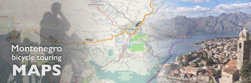
Bike Touring in Montenegro
This content was originally hosted at Meanderbug. They asked me to keep it live after they swapped the focus of their own site.
In addition to a country map that will be updated often, there are more detailed track maps below with a color-coded ranking and other info to help you plan your next bike tour in Montenegro.
In the future we will be delivering this content in different ways which will update on this post. Inter-Balkan routes will be accessible through the bicycle touring the Balkans page.
Our plan is to make .gpx data available for downloading to your GPS for all routes that we make available in the future.
We have more big plans for how to make info resources available to help our current and future bike touring friends.
Thanks in advance for anything you can do to help us with information, ideas, feedback, encouragement, and getting the word out to others.
We look forward to seeing and meeting you out there on the roads enjoying the beauty and hospitality that is the Balkans.
Montenegro bicycle touring map – countrywide

Montenegro is one of the prettiest countries in the world. It is the most bio-diverse country in Europe.
If you like mountains of various shapes and sizes, coastlines with vastly different beaches, icy-cold, crystal-clear rivers at the bottom of multiple world-class canyons, and both freshwater and saltwater fjords, then you’re probably going to like touring in this little country.
The beauty along with a hospitable people and Mediterranean climate are all on the plus side.
One challenge that all of the mountains and canyons necessitate is creativity when constructing roads.
Because of the logistical challenges, many of the roads are narrow and windy. We take all of this into consideration below in our ranking system.
Related: Cycling Across Europe
Bicycle Touring Tracks – Montenegro
Each track on our Montenegro road map has a green, yellow, or red color coding. This coding is relative to other track possibilities in the surrounding area.
Green will represent what we find and learn from others that are the safest options. Yellow has some type of challenge(s) that are manageable, but worthy of extra attention. Red tracks are not safe for cyclists to pass.
ROUTE – endpoints (color coded)
Distance; Ascent/descent total; min/max elevation; x/5 photo ranking.
MNE1
(coming soon)
MNE1 (8 maps) – Kolasin – Podgorica


MNE2 (4 maps) – Cetinje – Podgorica
31 km; 182/781 m; 33/671 m.; 3/5.
Mountainous terrain with climbs and scenic nature. Roads are narrow with traffic. Not a good place for a two-wheeled trailer.
Highlights include: *Lookout over Podgorica * Crnojevica River * Mountains * Wine region including Drušići


MNE3 (3 maps) – Budva – Cetinje
28 km; 885/296 m; 52/883 m.; 4/5.
Mountainous terrain with lots of climbs and gorgeous nature. Most of the track has a 3rd passing lane for vehicles allowing more room for all to maneuver.
Highlights include: *Crnojevica River * Mountains * Kosmać Fortress * View of the Adriatic.


MNE6 – Budva – Kotor junction (2 maps)
20.2 km; 170/195 m; 11/105 m.; 3/5.
Mountainous terrain with lots of climbs and gorgeous nature. Most of the track has a 3rd passing lane for vehicles allowing more room for all to maneuver.
Highlights include: * Coastal town of Budva * Mountains * View of the Adriatic


MNE7 – Kotor – Tivat
High traffic 4 km tunnel makes this unpassable on bicycle. Alternate routes include around the Boka Bay and over Mt. Lovcen.

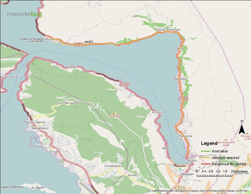
MNE9 – Kotor – Perast
13.7 km; 81/95 m; 9/59 m.; 5/5.
Coastal road along the Boka Bay. Congested in summer, but manageable year round.
Highlights include: * Kotor * Boka Bay * Perast
MNE10 – Kotor – Lovcen National Park
22.9 km; 950/32 m; 5/942 m.; 5/5.
Steep climb or big drop. Either way, lots of world class beauty to take in from the saddle. Narrow lanes with lots of switchbacks. Traffic is not real heavy and usually moves slow.
Highlights include: * Kotor mountain road * Mountains * Boka Bay

MNE11 (2 maps) – Cetinje – Lovčen National Park
20.8 km; 272/522 m; 687/1112 m.; 4/5.
Mountainous terrain with lots of climbs and gorgeous nature. Most of the track has a 3rd passing lane for vehicles allowing more room for all to maneuver.
Highlights include: *Crnojevica River * Mountains * Kosmać Fortress * View of the Adriatic.


MNE12 – Cetinje, Montenegro
2.9 km; 18/55 m; 630/690 m.; 3/5.
Passing through the former capital of Montenegro.
Highlights include: * Former capital * Lovčen National Park

MNE13 – Bar, Montenegro Map

MNE14 (2 maps) – Podgorica – airport


MNE15 – south of Podgorica airport bypass

MNE16 (2 maps) – Podgorica bypass – Virpazar
15.6 km; 42/16 m; 13/42 m.; 4/5.
Flat terrain with scenic nature. Roads are reasonable width with traffic.
Highlights include: * Skadar Lake * Mountains * Quiet town of Virpazar on the lake


MNE17 (2 maps) – bypass to Sutomore
Toll road with 4.1 km tunnel with moderate traffic is unpassable on bicycle. Alternate routes are Virpazar to Old Bar or toll road junction to Petrovac.


MNE19 (3 maps) – Bar – Virpazar
32.2 km; 960/1025 m; -3/774 m.; 4/5.
Old road now used very little by cars. Some gravel, large potholes, and street washouts along the way but passable and in use for bike touring. Proceed with caution.
Highlights include: * Adriatic * Mountains * Quiet town of Virpazar * Skadar Lake


MNE20 – Virpazar – tunnel junction

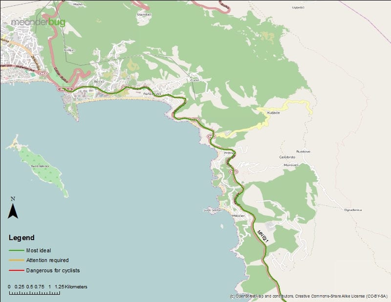
MNE21 (2 maps) – Budva – Petrovac

MNE22 (3 maps) – Danilovgrad – Podgorica
18.7 km; 28/44 m; 30/65 m.; 3/5.
New road with light traffic. Nice views with insight into a previous time with country life and Danilovgrad’s rural feel.
Highlights include: * Moraća River * Mountains in distance * Quiet town of Danilovgrad


MNE23 (2 maps) – Danilovgrad – Ostrog Monastery
21.3 km; 824/146 m; 26/751 m.; 4/5.
A climb toward Ostrog with scenic nature. Roads narrow as you near Ostrog. Minimal traffic.
Highlights include: * Quaint town of Danilovgrad * Mountains * Zeta Valley * Ostrog Monastery


MNE24 – Nikšić highway – Ostrog Monastery
8.7 km; 32/249 m; 413/644 m.; 3/5.
Connects the Podgorica-Nikšić highway with Ostrog.
Highlights include: * Zeta Valley * Ostrog Monastery * Homemade items for sale (e.g. juice, wine, honey, rakija)

MNE25 (4 maps) – Nikšič Highway to Podgorica
36.5 km; 68/46 m total; 34/426 m elevation; 3/5 photo ranking.
Riding on reasonably flat terrain with the Zeta valley on one side and mountain ridge line across from it. Yellow status because this road receives more traffic than newer road on the opposite side of the valley.
Highlights include: * mountains and sweeping valleys * Ostrog monastery in the distance


MNE26 (3 maps) – Bar – Ulcinj
25.4 km; 367/340 m total; -23/163 m elevation; 4/5 photo ranking.
A gorgeous track that undulates fairly gradually along the way. Mountains on one side, seawater on the other with many hundreds of years old olive trees on the southern portion. Traffic is heavy during summer season but manageable year-round.
Highlights include: * Adriatic * Mountains * Amazing olive trees


MNE27 (2 maps) – Bar – Petrovac
Petrovac to Bar bicycle touring map
Petrovac to Bar bicycle touring map 2


Bike Touring Maps Montenegro
Please share this blog post by pinning the image below!

Bicycle Travel in Montenegro
You might also be interested in:
- 3 months cycling Eurovelo 8
- Balkans Eurovelo 8 Route
- Biking the Kotor mountain road
- Bicycle touring Risan
- Biking to Kotor
- Camping outside Dubrovnik
- Balkan Wilderness Camping
- Day 15 My flexible bike tour
- Bicycle Touring Day 16 – Biking with Trolls (Eurovelo Route 8)
- Bicycle Touring Day 17 Along Eurovelo 8 – Visiting Slovenia
- Bike Touring Italy – Week 4 Cycling the Eurovelo Route 8
- Bicycle Touring the Hidden Treasures of Italy – Eurovelo 8 Week 5
- Bicycle Touring in Perugia, Italy – Week 6 Eurovelo 8
- Week 7 Eurovelo 8 Bike Tour: A Change of Plans
- Week 8 Cycling Eurovelo 8: Bicycle Touring in Italy
- Week 9: Bicycle Touring the Mediterranean
- Why does my bike rack wobble?